By David Somen
Date: Saturday October 9th 2010
The walk:
A 10 ½ mile circular walk on the Malvern Hills, Worcestershire, which has a number of steep gradients but shouldn’t prove too difficult for a regular walker.
Start: Swinyard Car Park
End: Worcestershire Beacon viewpoint and cairn.
Starting at the car park and following the farm track up to the Herefordshire Beacon (British Camp) (1,109 ft) descending to the A449 and then picking up the trail that leads across the spine of the hills, taking in:
Black Hill (south)
Black Hill (north) (1,011 ft)
Pinnacle Hill (1,174 ft)
Jubilee Hill (1,073 ft)
Perseverance Hill (1,066 ft)
Summer Hill (1,253 ft)
terminating at the viewpoint point on The Worcestershire Beacon (1,395 ft). Most of the climb is at an elevated height and therefore does not require each hill to be climbed from its base.
In clear weather there are sweeping views across Hereford and into the Black Mountains of Wales. The return journey takes a lower trail through pleasant woodland, before climbing the British Camp a second time and back down to the car park.
The route is easy to follow with clearly defined and well-made tracks throughout, so hazards such as mud and water are not usually a problem.
The weather can be changeable – particularly later in the year – so it is wise to dress accordingly.
So here I am supping a very nice Starbucks latte and thinking about the Malvern Hills walk Mark and I did two days ago….
The weather forecast promised light cloud with plenty of sun. At 7:15am as I stood outside my house waiting for Mark to arrive it was still too dark to reliably forecast the day’s weather for myself. Mark arrived duly on time. It was really nice to see his smiling face as this was only the second time in far too many years that we had been able to get together, chew the cud, and play catch-up. The 70 minute drive to Malvern passed really quickly. It was fun, informative and interesting, as we continued to catch up on our lives past, present and future. It also became evident pretty quickly that the weather forecast people had got it wrong once again. The day was going to be chilly, overcast and windy. Low cloud cover beckoned.
We arrived at the Malvern Hills around 8:30 am, parked at the Swinyard car park, and changed our shoes for sturdy walking boots.
 Normally I use two walking poles as I find it takes a lot of the strain off of my knees and gives a bit more zip to my step. On this occasion though I decided one was enough as I would be carrying my Flip Ultra HD video camera on a monopod in the other hand. I have to say though that I missed that second pole and in the future will have to think about how I will carry all of these things. It was interesting that Mark had never used two walking poles before. He normally uses one. When he had a go with two I wasn't totally convinced he was happy with them. Mark commented that he normally uses his walking pole rather like a gentleman's walking stick, lightly prodding the ground as he skips along and not for supporting his weight and balance. This made me smile. I will have to re-educate him.
I set off, relishing the hours ahead (although some people will no doubt say that these are 'just walks', I would point out that, in fact, each and every one of them is 'an adventure!').
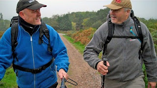
From the car park Mark took the lead. He had done this walk on previous occasions and knew the route off by heart. It was good to see him so fit and he reminded me of my walking pal Lloydy, especially when you see a pair of legs striding out in front of you up a steep gradient as they get further and further away. As I told Mark, I have the stamina but not always the speed.
As we climbed my legs and heart reminded me that it had been some months since I had done a sturdy walk. More than once I feared the Anglian Home double-glazed door I'd had built into my chest would break open and spill my burst heart onto the Malvern greenery. The bolts held tight though as we tackled the first climb up and over the Herefordshire Beacon, aka The British Camp, where ancient Iron-age ramparts and earthworks have shaped the hill into a series of terraces.
The fresh crisp air was just what I needed. There is nothing like a walk in the British countryside to revitalise you. Mark was in training and it showed. He plans to do the Three Peaks challenge next year. He made my planned Hadrian's Wall walk sound easy.
After the British Camp we crossed the A449 by the classy looking Malvern Hills Hotel and picked up the track that would lead us directly over the summit of the hills, where today we would reach the highest of them; the Worcestershire Beacon.
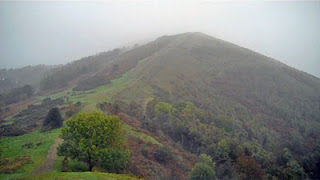
The wind, hardly noticeable at ground level, became a bully on higher ground, which made some of the gradients all the more difficult. We slowly ticked the hills off, Black Hill, Jubilee Hill, Pinnacle Hill, and our walk across their switch-back of summits went off without incident. Well, almost.
The pattern became typical of following someone who knows what they are doing but has forgotten the all-important details.
"The next hill is the toughest but don't worry, it's the last one!"
Followed by.
“Oh, did I say that was the last one? Err … I'm sure this one's the last one, honest!"
And so the conversation ran, as we trudged up the ‘last’ hill only to be confronted with another, even higher one ahead.

The sun might not have shone but at least it didn't rain. We watched the low moist clouds roll between the hills like drifting ghosts. Sadly, much of the beautiful scenery around the Malvern Hills was blocked from our view, but the task at hand steadied our nerve. I did almost lose my mental grip when a sudden gust of wind took my beloved UKUFONW baseball cap from my head.
"Noooooooooo!".
The day was saved by a young girl, aged around 14, who took off after it like a hare. I was very grateful to have it returned. Oh to have that sudden energy. Age can be so cruel......
An all too brief respite of water, chocolate, crisps and sarnies and we were on our way again. Mark obviously hadn't heard of the Dave Somen walking break time of one hour + toilet visit as fought for by our brother Mr Scargill. On this occasion I was prepared to bend the rules a little ;-)
The wind was buffeting up on top, proven several times by straps on my rucksack slapping me smartly across the face. I wanted to rip them from their stitches but what strength I had was powering my legs. Talking of equipment; I was interested to see Mark using a hydration pack. I've had one for a few years but never used it. I will dig it out for next time.
Our walking pace and minor refreshment break meant we were making good time. We started our descent down off the hills, taking a track lower down on the western flank of the hills to lead us back to the car. After a long, hard, but above all enjoyable walk it's nice to know that it won't be too long before one can rest those aching sinews. Most walkers will agree that the descent is more painful than the ascent. More stress is put on the knees and ankles and more injuries caused. The Malvern Hills have steps in various places to assist the walker but Mark and I agreed that side stepping the steps and using the natural rise and fall of the landscape was in fact easier. A promise of a cafe with friendly wenches serving tea and coffee back at the A449 spurred us on.
Eventually, after following a long path, the little roadside kiosk greeted us and thankfully it was open!
They were doing a fair trade judging by the numbers of bikers and other walkers who were supping nearby. I took Mark’s order and patiently queued for two teas. A smiling woman behind the counter turned to me.
"Are you being served?"
I responded with my order for two teas, please, but then realised I may have queue-jumped the 6' 4" pony-tailed bloke to my left.
I began to make amends. “Oh sorry, this gentleman is first," I said, indicating the vague figure to my side.
The 'bloke' stepped forward and turned out to not be what I thought.
"LAYDee!!" she shot at me indignantly.
I turned my face away because it took all of my self-control not to have a fit of the giggles. I muttered an apology, stepping away to another part of the counter where I was eventually served. Goodness only knew what Mark was doing, as he was stood right behind me when I made this gaff.

[Note from Mark: I was turned away as well, facing the road and trying not to guffaw]
I loved Mark’s comment later on Twitter about her being the 'horsey type'. With all due respect to horsey types, that comment said it all. It wasn’t over either, with hot teas in our hands we crossed the road to a free bench next to another bench with a woman seated upon it.
Mark pointed her out. "I bet that's Horsey Type’s friend". And sure enough, it was.
Horsey Type crossed the road and sat with her friend no more than a yard away from us. I really did think of apologising again but I think it would have made a bad job much, much worse. I'll never forget that moment though. It makes me laugh every time I think of it.
A short but taxing climb back over the British Camp and a pleasant descent along a bracken fringed track and we were back at Marks car with our walking day almost over and better than ten miles completed. The few aches and pains we shared, probably more age related than lack of fitness, were soon forgotten, although later in the day when I stood, sat or walked, my protesting muscles reminded me pleasantly of a brilliant day with an old friend.
Both of us are long time walkers but this is the first time we have ever hiked together.
Long may it continue.
A Flickr gallery of this walk can be viewed here


