
| The Wye Valley Way | |
|
|

|
|
|
Whitebrook revisited ...
I woke expecting the accumulated consequences of the previous day to have arrived overnight and found, to my considerable surprise, that they hadn't. No stiff legs, no protesting muscles, nothing that couldn't be managed with a cup of tea and moderate optimism. We were about to walk twelve miles and the body appeared to have either recovered or decided not to make a scene about it, and either outcome was welcome. Today was promised to be the Yin to yesterday's Yang — a flat march along the riverbank rather than the relentless gradient-climbing of Day One. The Wye Valley Walk has this pattern to it, as I had noticed in the planning: a hard day followed by an easier one, the route alternating between the forested hillsides above the gorge and the level ground beside the river.
 |
Relics of an industrial past at Whitebrook. |
Yesterday had been thoroughly Yang. Today, with the river as our compass and the ground beneath us broadly horizontal, had the makings of something more forgiving.
We set out mid-morning from Whitebrook under a dull and damp sky that showed no particular ambition to rain. The village is a small thing now — attractive cottages, a smart restaurant — though in earlier centuries it was industrious and notable for the quality of the paper it produced. Bank notes and wallpaper, made from imported rags in mills powered by the valley's streams. The ruins of one such mill stood by the path as we left, its old walls carrying the outline of waterwheel pits and leats, the stream running quietly past the remains of an industry it once drove.
We passed Tump Farm and looked up at the high pastures where we had wandered hopelessly lost the previous evening. The bull who had been kicking something large and solid in the gathering dark was absent this morning. The smell of cow manure was not. The guide turned us sharp left just past the farm — onto a path we now realised we were never meant to leave the previous day. Two wrong turns in five minutes, and an extra six miles. We had earned our ache.
Redbrook – rain stopped play ...
The river was our guide and the navigation, in theory, was simple: follow it north and don't lose it. We joined the Wye on a broad green track that had been the bed of the Wye Valley Railway line — eighty-three years of carrying passengers between Monmouth and Chepstow, from 1876 until its closure in 1959, replacing the riverboats and trows that had worked the valley before it, and now replaced in turn by walkers. It was flat, straight, and entirely welcome. Sheep grazed on the opposite bank under wooded hillsides. The river glided without apparent urgency. We ambled in the kind of companionable solitude that flat walking beside water produces, stopping at one point to examine a carved wooden sculpture of a brace of salmon that had been positioned — or possibly abandoned, it was genuinely difficult to tell — beneath the trailing cover of a hedgerow.
Redbrook Bridge was the first bridge of the day, another former railway structure, alongside a building that appeared to be attempting several identities simultaneously — post office, pub, café, and B&B all competing for the same frontage. The river here serves as the border between England and Wales, and we crossed from the Welsh bank into England and the riverside village of Redbrook.
 |
On the banks of the Wye. |
The rain started as soon as we stepped onto English soil. This felt deliberate.
We knew Redbrook from the Offa's Dyke walk and the Bell Inn from two evening meals on that previous occasion. It was open. We presented our passports for stamping and ordered swift ales, hoping the rain would take the hint. It didn't quite stop, but it reduced to a fine drizzle, which was a negotiating position we could work with.
On the large village green by the riverbank, a bank holiday fête had been assembled: marquees, stalls, a bouncy castle. The rain had largely defeated it. A scattering of people in waterproofs moved between the tents with the stoic determination of those who have paid for their pitch and intend to occupy it regardless. Children jumped in puddles or bounced splashily on the castle; impervious to weather. The stallholders exchanged greetings with each other for want of customers. We sat at a bench with our lunches amid the sagging bunting and felt a mild sympathy for all concerned.

Upstream to Monmouth ...
We left Redbrook and followed the English bank across a long series of meadows, broad and for the most part featureless — except for one substantial field given over to the Monmouthshire Show Society for agricultural events, deserted today, where I ducked into a marquee to answer an urgent call of nature. I record this in the spirit of honest reportage and apologise to the Society. The path moved into scrubby woodland and the tree roots reappeared with the persistence of old adversaries, the ground damp enough to keep them properly treacherous. We had walked this stretch before, in the opposite direction, on a visit to the Kymin some years earlier, and the landmarks came back as we reached them: first the sandstone buttresses and archways of the
 |
Approaching Redbrook via the old iron railway bridge. |
 |
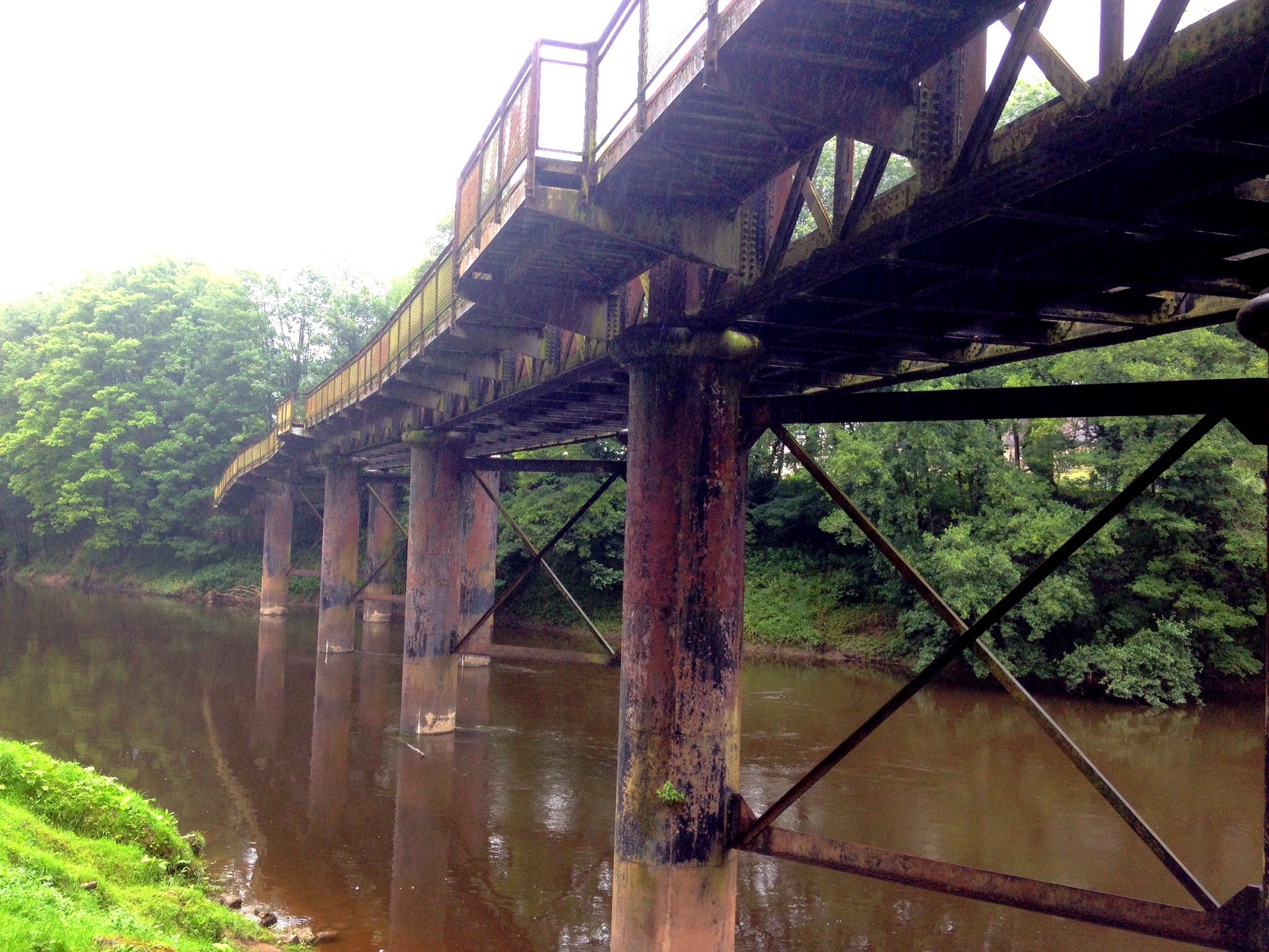
The remains of the Wye Valley Railway Monmouth Viaduct |
Just past Monmouth the hub of all the canoeing activity was reached, the Monmouth Canoe Hire and Activity Centre which is a bit of a mouthful even if you reduce it to an acronym. The MCHAC was certainly doing a brisk trade, with a large party of life-jacketed canoeists about to launch and another big group arriving via mini-bus.
We passed what remains of the old Monmouth Quay and continued along the riverside path.
St. Peters at Dixton stood dangerously close to the river's edge — a position it has held since the twelfth century, surviving the Wye's regular flooding with the patience of something that has accepted the terms and intends to continue regardless. The iron gates and steps leading down to the water are a remnant of the days when a ferry crossed here and the vicar would row across from his vicarage on the opposite bank to hold services. The border between the Church of England diocese of Hereford and the ecclesiastical territory of Wales runs through this building, which seems a suitable ambiguity for a church at the edge of things.
Beyond Dixton, the A40 ran parallel to our course and then gradually peeled away north as the river curved east. The road noise faded to a muted swish and then to silence, and the walk settled back into the particular quiet of the Wye valley.
Hornets and hounds ...
We were back in woodland, picking our way over gnarly roots and through dark hollows where hart's tongue fern grew in thick colonies and fallen trunks had been comprehensively colonised by moss. A small concrete platform with an iron railing served as a viewpoint above the river, and below us a man was fly-fishing — standing waist-deep in the current, flicking his rod back and forth with the practised ease of someone who has made peace with the fact that the fish are in no hurry. We stopped to watch for a moment, admiring the skill.
 |
St. Peter's Church, Dixton. |
The woodland beyond this was very pretty and entirely peaceful, which we appreciated all the more for the contrast. Here and there, remnants of older occupation appeared through the trees: a section of old stone wall with an ancient wooden door that opened onto a wild glade and nothing else, and a rusting iron fence with a gate still locked on whatever it was once guarding, the forest trail swerving around it with the mild contempt of a path that has been here longer than the fence and intends to remain here after it.
We passed Wyastone Leys on its slight rise to the left — a handsome country house originally built in 1795 and rebuilt in the 1830s by the industrialist Richard Blakemore, who extended the estate to include a landscaped deer park and an iron tower folly. A small herd of fallow deer are still kept at the edge of the Little Doward hillfort behind it. Since the early 1970s the estate has been home to Nimbus Records, one of the pioneers of compact disc manufacturing, which gives Wyastone Leys the unusual distinction of combining a Victorian deer park with a classical music recording studio and occasional public concerts.
The path continued into Forest Of Dean territory — Colin and I have had directionally challenged moments in the Forest before and we noted the fact — until a large cliff face appeared in a clearing to our right. Twenty metres or so of sheer limestone face, too regular and vertical for nature, which we correctly identified as quarrying. The cliff is known as the Seven Sisters Rocks, and the limestone was once shipped downriver for building and lime-making. Above it, out of sight from the path, King Arthur's Caves contain evidence of human presence from twelve thousand years ago, before the last ice age, along with the remains of mammoth, woolly rhinoceros, and sabre-tooth tiger. I had taken my daughters to see the caves years before and remembered them as genuinely impressive. Arthur's connection to them is, as with most things Arthur, considered unlikely by the historians. The caves are currently home to colonies of lesser and greater horseshoe bats.

A bouncy bridge and a long last mile ...
The woodland released us at the Biblins Youth Campsite, where blackberries were just coming into their own and we spent a few minutes picking and tasting. Some were excellent. Others were essentially lemon. You took your chances.
The Biblins Suspension Bridge was busy with families and dogs. A notice restricted the bridge to twelve persons at a time, which a party of sixteen ahead of us interpreted as a guideline. We waited as they stamped across, then set off ourselves. I had crossed it years before and it seemed much as I remembered — though it is apparently a newer version, access ramps having replaced the wooden steps I must have used on the earlier visit. It is a narrow footbridge on thick steel hawsers, and it moves. The whole structure bounces and sways and squeaks with an enthusiasm that some people find alarming and others — fewer — find entirely reassuring. Behind me I heard Colin savour the word *Plummet* as he contemplated the considerable quantity of air between the footway and the river below. The crossing is perfectly safe. It just doesn't feel entirely so while you are doing it.
 |
Mark crossing Biblins Bridge. |
Our legs had been noting, quietly but persistently, that yesterday's six unplanned extra miles had not been forgotten by the body even if the body had declined to mention it at breakfast. The final mile to Symonds Yat East was the longest mile of the day, and by the time we reached the hubbub of the village and found a table at the Saracens Head overlooking the river, sitting down felt like the finest thing available to us.
The Saracens Head was the third passport stamp station of the walk. We collected our stamps, ordered pints, put our feet up, and watched Symonds Yat East conduct its business, which consisted largely of bicycles and canoes. The hand-pulled chain ferry worked steadily between the two banks — a wooden pontoon affair, dragged across by cable, operated by a ferryman leaning into the work. It looked demanding. In high summer, apparently, it can be lucrative, and the position is keenly sought. The rapids downstream, formed from the collapsed weir of a seventeenth-century ironworks that once refined iron on the opposite bank, churned white and inviting below the pub garden.
Goodbye to the Wye … for now ...
That was the end of Day Two. As it turned out, it was also the end of the Wye Valley Walk for the year. Life intervened in the way that life does, and it would be the spring of 2016 before Colin and I could get back out on the path — Days Three and Four waiting ahead of us, with the familiar meadows of Welsh Bicknor, a pass within a stone's throw of Brock Cottage, the city of Hereford, and then the less familiar territory of the Welsh borders and the long approach to Hay-on-Wye.
The river would be there when we came back. It always is.
For a full profile of the route (PDF format) click here
See Route on ......
|
|
|
|
|
 Prev
Next
Prev
Next

No comments:
Post a Comment